BATCH DOWNLOADING: You can use wget to download data quickly. For example if
you want to download all the v07 interpolated files from Africa for August of 2014, you could use this command. Don't forget the
slash (/) at the end of the URL.
wget --debug --tries=10 --http-user=[login] --http-password=[password] --no-host-directories -r -A .nc http://gpm.atmos.washington.edu/v07/AFC/interp_data/2014/08/
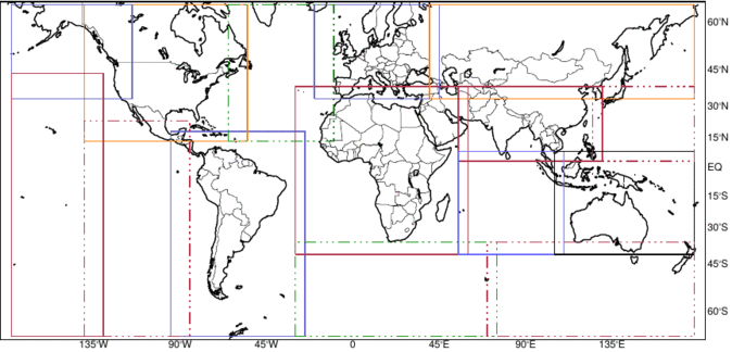
The data are stored by regions of the globe, represented by the boxes in the map above. By clicking inside a box on the map, the user will go to the page containing the analysis products for that selected region. One can accomplish the same thing by going here and clicking on the region of interest.
The NASA GPM 2AKu product is provided in bins along the slant range of the antenna beam. In the University of Washington database, these data in radar coordinates are geolocated and interpolated into a three-dimensional Cartesian grid and stored for analysis. From this dataset it is possible to identify structures of reflectivity echoes that satisfy certain criteria. Five types of echo objects are identified: shallow isolated echoes (SHI), deep convective cores (DCC), wide convective cores (WCC), deep-wide convective cores (DWC), and broad stratiform rain areas (BSR). Specific, defining characteristics of each of the objects are defined in section 4, below.
For all the classifications, the calculations are based on two different sets of thresholds - strong (str) and moderate (mod). Each object identified by these criteria is provided in netcdf format in both gridded (grd) (dimensioned by latitude and longitude) and tabular (tab) (dimensioned by instance or case) form. These gridded and tablular netcdf files contain information of the monthly climatology and individual properties of the identified echo objects. So, for example, the broad stratiform data from January of 2015 is contained in 4 files - strong thresholds and gridded, strong thresholds and tabular, moderate thresholds and gridded, and moderate thresholds and tabular. In addition, convective, stratiform and shallow isolated CFADs (Contoured Frequency by Altitude Diagrams) of reflectivity and drop size diameter (Dm) are included as gridded files for each threshold type.
In order to identify the echo objects (SHI, DCC, WCC, DWC, BSR), the raw GPM data are subjected to the following, specialized processing.
The UW database contains information on five types of radar echo objects derived from the interpolated Cartesian data described above.
Each of the core echo objects -- BSR, DCC, DWC and WCC -- is usually embedded in a larger storm. The statistics for each event in the tabular output describie both the core and its associated storm. Each core and storm are also identified by 2-dimensional masks in the interpolated data files. Since some storms contain more than one echo object of a particular type, each core is identified by a core_id. The core_id is included in both the tabular data and the appropriate mask variable in the interpolated data. For example, if a storm contains three different DCC objects, they are numbered 1, 2 and 3 in the tabular output and the correspoinding DCC mask is filled with 1's, 2's and 3's at the appropriate grid points. All remaining points in the mask are filled with the missing value.
The file naming convention is consistent throughout the website. The files are stored in directories first by region and then by data type.
For the interpolated data (in subdir 'interp_data'), the convention is: [TRMMversion]_[UWversion]_[start_yyyymmdd].[start_hhmmss]_to_[end_yyyymmdd].[end_hhmmss]_[orbit]_region.nc where
So a typical filename might look like this - 'GPM2Ku7_uw4_20220314.071742_to_20220314.072050_045683_AFC.nc'. This file would contain interpolated data from the Africa (AFC) region for orbit 45683 on 14 Mar 2022 from 071742Z to 072050Z.
For the classified radar echo objects (in subdirs 'BSR', 'DCC', 'DWC', 'SHI', 'WCC'), the convention is: [TRMMversion]_[UWversion]_[classification]_[threshold]_[type]_[yyyymm]_[region].nc. where
So a typical filename might look like this - 'GPM2Ku7_uw4_BSR_str_tab_201412_SAM.nc'. This file would contain broad stratiform (BSR) data based on strong (str) thresholds in 'tabular' format (tab) for December of 2014 for the South America (SAM) region.
For the cfad data (in subdir 'cfad'), the convention is: [TRMMversion]_[UWversion]_[cfadVar]_[classification]_[threshold]_[type]_[yyyymm]_[region].nc. where
So a typical filename might look like this - 'GPM2Ku7_uw4_DmCfad_stra_str_grd_202201_AFC.nc'. This file would contain broad stratiform (stra) data based on strong (str) thresholds in 'grid' format (grd) for January of 2022 for the Africa (AFC) region.
Since our analyses is based on a series of regional studies which will eventually span most of the globe, the data is meant to overlap at the edges of all the global regions. It is suggested that if a user needs to combine information from two or more regions for a singular analysis, a careful 'stitching' of the data must be accomplished to avoid identifying overlapped echo elements multiple times.
Erich Stocker of NASA/Goddard Spaceflight Center provided invaluable help with the processing of the data and products provided via this website.
In all publications and presentations based on the information
provided via this website, please acknowledge the University of Washington
with a statement like this: "Data for this study comes from the University of
Washington GPM-Ku Data Set located at http://gpm.atmos.washington.edu" and
supported by the NASA Earth Sciences PMM Program.